On September 23, at the international conference IDAACS 2021, a student of FTI NTUU «Igor Sikorsky Kyiv Polytechnic Institute» presented the work «Validation of the Global Human Settlement Layer and NASA Population Data for Ukraine», performed within the project «Geospatial models and information technologies for satellite monitoring of smart city» (Competition of the National Research Foundation of Ukraine «Support for research of leading and young scientists»).
The article already briefly describes the purpose of the work, but it is not superfluous to tell in more detail about the current topic of validation of global products of population density monitoring using the latest methods using satellite data, citing what has already been said:
«Today, there are many ways to conduct a census, but the methods used in Ukraine still require a large amount of human resources and materials, which is not the best option in 2021. World practice has already been able to involve satellite images in the process described above. Artificial intelligence uses special algorithms to process satellite images and calculates the approximate number of inhabitants in the study areas. This allows us to calculate the number of inhabitants where there is no direct communication, ie in this way it is possible to estimate the number of inhabitants in eastern Ukraine. The paper checks the accuracy of satellite data to determine the feasibility of using this method of population assessment in Ukraine».
To verify the population data, official population statistics for 2015-2020 were used for the 20 largest cities in Ukraine. A separate inspection was conducted in the districts of Kyiv for which statistical information on the population for 2007-2021 is available. Population data were obtained from the Global Human Settlement Layer (GHSL) and NASA images.
GHSL data are only available for 2015, and NASA population data are available for 2015 and 2020.
An example of a GHSL product for Ukraine is provided below.
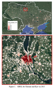
Sophia spoke in detail about GHSL, explaining in simple terms how this method works, and listed the quantitative factors on which the human presence on the planet is based.
We also now know from Chinese scientists that GHSL , as a rule, underestimates the building density of low-density areas and increases the density of high-density areas. This characterizes GHSL as a good indicator for population disaggregation.
As a result of the work performed by the student of FTI, the population was determined in each place, the Pearson correlation coefficient was calculated and the values of absolute and percentage errors were calculated, after which it was found that the error increases when moving west (except there are cities of Khmelnytsky and Rivne).
In order to carry out such work, you need not only the desire, but also significant knowledge. Knowledge that can be obtained where it is customary to gnaw the granite of science — at the institute, namely — at the Institute of Physics and Technology, as well as Sofia. We are proud of our students and we want everyone to be able to immerse themselves in science with their heads!