The international conference IDAACS 2021 took place on September 22-25, at which the teachers of the Department of Mathematical Modeling and Data Analysis presented their works together with the students:
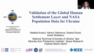
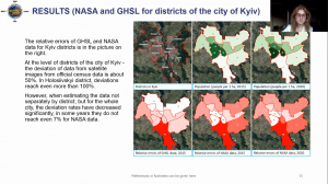
1. Validation of the Global Human Settlement Layer and NASA Population Data for Ukraine, Nataliia Kussul, Hanna Yailymova, Sophia Drozd, Andrii Shelestov.
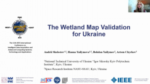
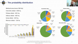
2. The Wetland Map Validation for Ukraine, Andrii Shelestov, Hanna Yailymova, Bohdan Yailymov, Artem Chyrkov.
3. Automatic Deforestation Detection based on the Deep Learning in Ukraine, Leonid Shumilo, Mykola Lavreniuk, Nataliia Kussul and Bella Shevchuk.
All these works have been completed and will be further developed within the framework of competitions of the National Research Foundation of Ukraine, which received grant support at NTUU «Igor Sikorsky Kyiv Polytechnic Institute». In particular:
1. 2020.02/0284 “Geospatial models and information technologies of satellite monitoring of smart city problems” (National Research Foundation of Ukraine Competition “Leading and Young Scientists Research Support“).
2,3. 2020/01.0273 “Intelligent models and methods for determining land degradation indicators based on satellite data” (National Research Foundation of Ukraine Competition “Science for the safety of human and society“).
IDAACS (International Conference on Intelligent Data Acquisition and Advanced Computing Systems) is the eleventh international conference on intelligent data acquisition and advanced computing systems, which promotes cooperation between the former Eastern and Western Europe and with countries around the world.
The first work «Validation of the Global Human Settlement Layer and NASA Population Data for Ukraine» was presented by Sophia Drozd, a student of the Institute of Physics and Technology of NTUU «Igor Sikorsky Kyiv Polytechnic Institute».
Today, there are many ways to conduct a census, but the methods used in Ukraine still require a large amount of human resources and materials, which is not the best option in 2021. World practice has already been able to involve satellite images in the process described above. Artificial intelligence uses special algorithms to process satellite images and calculates the approximate number of inhabitants in the study areas. This allows us to calculate the number of inhabitants where there is no direct communication, ie in this way it is possible to estimate the number of inhabitants in eastern Ukraine. The paper checks the accuracy of satellite data to determine the feasibility of using this method of population assessment in Ukraine.
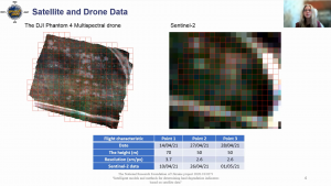
Hanna Yailymova, Assistant of the Department of Mathematical Modeling and Data Analysis Institute of Physics and Technology NTUU «Igor Sikorsky Kyiv Polytechnic Institute», made a presentation on «The Wetland Map Validation for Ukraine», talking about the technology of validation of land classification maps, including maps bogs obtained on the basis of satellite time series and on the basis of neural networks and deep learning, which since 2016 is being developed by the Space Research Institute NAS Ukraine and SSA Ukraine in cooperation with NTUU «Igor Sikorsky Kyiv Polytechnic Institute».
The work «Automatic Deforestation Detection based on the Deep Learning in Ukraine» highlights the problems of illegal logging on the planet and in Ukraine in private. The system of tracking the dynamics of forest cover change in real time with the help of in-depth training and satellite data is presented. Bella Shevchuk, a student of KAU, stressed that to implement this approach to automatic use, combined optical and synthetic aperture radar images of satellite missions Sentinel-1 and Sentinel-2, in which objects are detected using a neural network based on U- Net, trained using reinforcement learning techniques. The paper shows how the Cutting Detection System works within the Kyiv region.
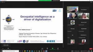
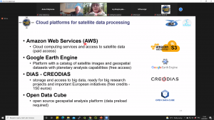
It is worth noting that Professor Nataliia Kussul became a guest speaker of Oral Session FB3: 5. Computational Intelligence for Instrumentation and Data Acquisition Systems and made a report on «Geospatial intelligence as a driver of digitalization», which is about the era of large satellite data , new horizons, machine learning and digitalization of the economy. One of the most important issues covered is – where to start Ukraine’s path to the ERA?
In addition, Nataliia was a session chair of the section «Advanced Mathematical Methods for Data Acquisition and Computing Systems», where participants discussed the visualization of regulatory and evolutionary processes on the path to climate change, the official verification of seamless cryptographic unlocking in real-time communication systems. assessment of informative parameters based on the neural network approach during geotechnical system monitoring and optimization of positioning of drone systems.

Each of the works is a powerful innovation in the field of technology and a push to solve many problems that are among us. It is through bold ideas and the desire for change that every concept will definitely be implemented at its best.
Get involved!