The IGARSS 2021 International Conference took place on July 12-16, 2021. Among of 2177 submitted materials the staff of the Space Research Institute NASU-SSAU and the Institute of Physics and Technology of National Technical University of Ukraine «Igor Sikorsky Kyiv Polytechnic Institute» the results of own works were presented:
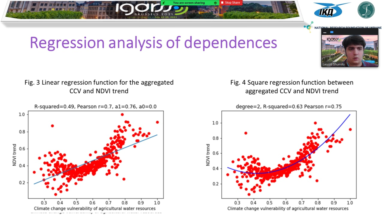
- Relationships Between Land Degradation and Climate Change Vulnerability of Agricultural Water Resources, Nataliia Kussul, Leonid Shumilo, Loukas Garanis (2020.01/0273);
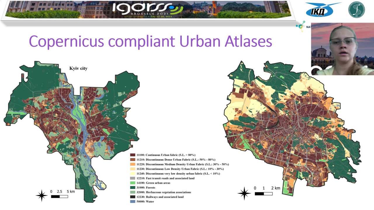
- Extension of Copernicus Urban Atlas to non-european countries, Andrii Shelestov, Hanna Yailymova, Bohdan Yailymov, Leonid Shumilo, Alla Lavreniuk (2020.02/0284);
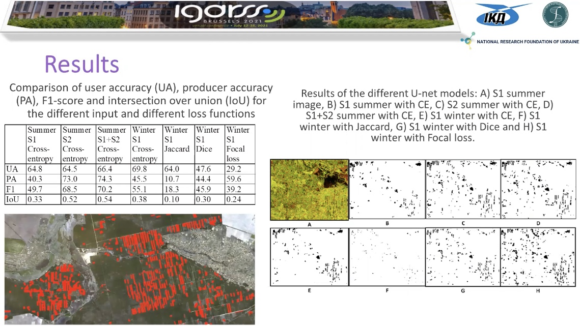
- U-net model for logging detection based on the Sentinel-1 and Sentinel-2 data, Leonid Shumilo, Nataliia Kussul, Mykola Lavreniuk (2020.02/0292).
All these works have been performed and will be further developed within the competitions of the National Research Foundation of Ukraine. He received grant support from the National Technical University of Ukraine «Igor Sikorsky Kyiv Polytechnic Institute» and the Space Research Institute NASU-SSAU. In particular:
- 2020.02 / 0284 «Geospatial models and information technologies of satellite monitoring of smart city problems» (competition of the National Research Foundation of Ukraine «Support for Research of Leading and Young Scientists»);
- 2020.01 / 0273 «Intelligent models and methods for determining land degradation indicators based on satellite data» (competition of the National Research Foundation of Ukraine «Science for Human Security and Society»);
- 2020.02 / 0292 «Methods and models of in-depth training for applied tasks of satellite monitoring» (competition of the National Research Foundation of Ukraine «Support for Research of Leading and Young Scientists»).
IGARSS (International Geoscience and Remote Sensing Symposium) is the largest annual symposium on remote sensing, which is attended by scientists from all over the world.
Leonid Shumilo was session co-chairs «TH2.MM-3: Object Extraction in Optical Images» and presented the work «Relationships Between Land Degradation and Climate Change Vulnerability of Agricultural Water Resources». The work was developed together with undergraduate Lucas — a student of the University of Geneva, who thanks to his supervisor Gregory Giuliani came for a summer internship at the Institute of the Space Research Institute. As a result of the cooperation, it was possible to analyze the impact of climate change on land degradation.
Hanna Yailymova made a presentation on the topic «Extension of Copernicus Urban Atlas to non-European countries». Hanna spoke in detail about the unique product, which currently exists only for European cities. Nevertheless, the staff of the Institute of Physics and Technology is developing and implementing technology for obtaining a similar product for Ukraine within the project of the National Research Foundation of Ukraine «Geospatial models and information technologies of satellite monitoring of smart city problems». The first steps in creating an Urban Atlas for the cities of Ukraine were made within the SMURBS project.
The work «U-net model for logging detection based on the Sentinel-1 and Sentinel-2 data» developed an automated satellite monitoring system of Ukrainian forests Deep Green Ukraine, which is implemented by the Space Research Institute NASU-SSAU, National Technical University of Ukraine «Igor Sikorsky Kyiv Polytechnic Institute», PO «Government Monitoring Center» and PO «Forest Initiatives and Society». The development of Deep Green Ukraine was made possible by winning the Open Data Challenge, held within the USAID / UK aid international technical assistance project «Transparency and Accountability in Public Administration and Services / TAPAS» with the support of the Ministry of Digital Transformation of Ukraine.
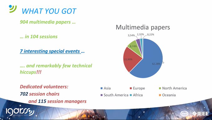
According to the statistics of the conference in 2021, a total of 904 papers were presented at 104 different thematic sessions (link).